Standing at 633m, Bleaklow Head is the second-highest point in the Peak District National Park and a challenging yet rewarding hike. Located in the Dark Peak, this peat-covered, gritstone-laden moorland is known for its boggy terrain and navigational challenges. The 8.0-km loop trail from Snake Pass follows the Pennine Way, passing Hern Stones and Wain Stones before reaching the summit cairn. On clear days, you can see Manchester, Hope Valley, and even Eryri National Park in North Wales.
Adding to its intrigue, Bleaklow is home to the remains of a B-29 Superfortress that crashed in 1948, killing 13 crew members. The scattered wreckage still rests on the moorland, with a memorial erected by the Royal Air Force in 1988. The trail continues to Higher Shelf Stones, then loops back via Crooked Clough to Snake Pass. Expect boggy conditions, and arrive early in summer months to beat the crowds.
| Attribute | Details |
|---|---|
| Hill | Bleaklow Head |
| Name | Bleaklow Head |
| Region | 36: Lancashire, Cheshire and S Pennines |
| Area | The Peak District |
| County/UA | Derbyshire |
| Topographical Area | EP07 Kinder-shining |
| Nuttall/Wainwright Area | The Peak District |
| Height | 633m / 2077ft |
| Drop | 128m |
| Col | 505m (SK065901) |
| Parent (Ma) | 2807 Kinder Scout |
| Classification | Hu, Sim, Hew, N, E |
| Class List | Hump, Simm, Hewitt, Nuttall, Ethel, Buxton & Lewis, Bridge, Clem (Hu, Tu, Sim, Hew, N, E, BL, Bg, Cm) |
| Feature | Tiny cairn on peat hag |
| Observations | Cairn is 0.75m higher than top of large cairn 50m W at SK 09415 96075 |
| Grid Ref | SK 09462 96068 |
| OS Map Sheet(s) | 1:50,000 – 110 / 1:25,000 – OL1W |
| Catchment | Catchment Boundaries, Mersey, Trent |
| Watershed | Humber Estuary, Ardnamurchan Point to Lowestoft, Cardiff to Cape Wrath, Dover to Cape Wrath, Lowestoft to Duncansby Head, Land’s End to John o’ Groats, Liverpool Bay, The Lizard to Dunnet Head |
Exploring Bleaklow: Routes and Highlights
Bleaklow Route Summary – Your Path to Adventure
Bleaklow is a wild and rugged moorland that promises an unforgettable hiking experience. Whether you’re a seasoned trekker or a weekend explorer, the right route can make all the difference. But with its vast, windswept terrain and hidden trails, where do you start?
In this section, we’ll break down the best routes to Bleaklow Head, helping you navigate the most scenic, challenging, and rewarding paths this remote Peak District gem has to offer. From gentle climbs to dramatic ridges, each trail has its own unique charm.
Ready to take on the Peak District’s second-highest summit? Let’s explore the top hiking routes that will lead you to Bleaklow’s breathtaking views and hidden wonders. 🚶♂️🏔️
South Bleaklow – A Wild and Rewarding Challenge
Looking for a hike that tests your endurance while offering some of the most untamed landscapes in the Peak District? South Bleaklow delivers exactly that. Known for its rugged peat bogs, steep climbs, and unpredictable weather, this route is not for the faint-hearted—but if you love the thrill of the wild, this is the place to be.
🌿 What Makes South Bleaklow Special?
This area is a true wilderness, where vast moorland stretches for miles, and the only sounds are the whispers of the wind and the crunch of your boots on the peat. Expect deep grouch’s (peat trenches), exposed plateaus, and an ever-changing trail that keeps you on your toes.
🚶 Best Routes in South Bleaklow
- Doctor’s Gate Path – A historic Roman road leading into the heart of Bleaklow, offering a challenging but scenic ascent.
- Torside Clough – A steep and dramatic approach with rewarding views of the Longdendale Valley.
- Shelf Stones Route – A lesser-traveled path that takes you through Higher Shelf Stones and the Bleaklow Bomber crash site.
If you’re after a tough but exhilarating hike with stunning panoramic views, South Bleaklow should be on your list!
North Bleaklow – A Remote and Underrated Gem
North Bleaklow is one of the most isolated and untouched areas in the Peak District, making it perfect for those who love the feeling of true wilderness hiking. Here, you’ll find vast plateaus, hidden groughs, and challenging navigation, making it a favorite among experienced hikers.
🌿 What to Expect in North Bleaklow
- Open, featureless terrain that requires solid navigation skills—map and compass recommended!
- Hidden peat groughs that create a maze-like feel—perfect for those who enjoy a navigational challenge.
- Spectacular solitude—unlike the more popular routes, you might not see another soul for miles.
🚶 Best Access Points for North Bleaklow
- Access via Snake Pass (A57) – A common starting point for those tackling Bleaklow Head from the north.
- Near Featherbed Moss – A quieter approach that offers sweeping moorland views and a sense of complete isolation.
If you crave an off-the-beaten-path adventure where navigation skills are key, North Bleaklow is waiting for you!
East Bleaklow – Where Scenic Views Meet Wild Beauty
East Bleaklow is the hidden gem of the area, offering some of the most scenic and rewarding views in the Peak District. While still remote, the terrain here is slightly easier to navigate compared to North Bleaklow, making it a great choice for those looking for a balance of challenge and beauty.
🌿 Why Hike East Bleaklow?
- Stunning views over the Derwent Valley—perfect for photographers and nature lovers.
- Unique rock formations like the eerie Hern Stones, a must-see on this side of the moor.
- Less boggy than other areas, making it a slightly more approachable route.
🚶 Best Navigation Tips for East Bleaklow
- Follow the Pennine Way – A well-trodden path that provides a reliable guide to this wilder section of Bleaklow.
- Use the Hern Stones as a landmark – This distinct rock formation helps with orientation in the open moorland.
If you’re looking for a hike that combines stunning Peak District scenery with a true sense of remoteness, East Bleaklow is an absolute must!
Bleaklow: Torside and Near Black Cloughs
If you’re looking for a trail that’s both breathtaking and adventurous, the Torside and Black Cloughs route should be high on your list. Nestled in the western edge of Bleaklow, this area offers a mix of steep ascents, rocky cloughs, and hidden waterfalls, making it one of the most scenic hikes in the Peak District.
🌿 What to Expect on This Trail
- Start from Torside Reservoir, where stunning views of Longdendale Valley set the stage for your hike.
- Follow the Torside Clough trail, a steep but rewarding climb that weaves through gritstone cliffs and open moorland.
- Venture into the Black Cloughs, a hidden gem with cascading waterfalls and mossy ravines—perfect for a quick photo stop or a moment of solitude.
🚶 Pro Tip: After heavy rain, the waterfalls in Black Clough are even more dramatic—so bring a camera and prepare to be amazed!
Bleaklow and Westend Circuit
Want to experience Bleaklow’s raw beauty in one epic loop? The Bleaklow and Westend Circuit is your answer. This challenging 10-mile hike takes you across vast peatlands, remote ridges, and historic landmarks, offering a complete Bleaklow experience.
🌿 Hike Highlights:
- Start from Derwent Reservoir and follow the scenic Westend Valley, a peaceful stretch of moorland.
- Climb towards Bleaklow Stones, a bizarre and otherworldly collection of weathered gritstone formations.
- Pass through Grinah Stones and Barrow Stones, two hidden rock clusters that few hikers get to see.
- Loop back via Alport Castles, one of the largest landslips in the UK, before descending through stunning woodland trails.
🚶 Best For: Experienced hikers looking for a full-day adventure with spectacular scenery.
Ashton Clough, Yellowslacks Brook, and Bleaklow
If you love finding off-the-beaten-path trails, then Ashton Clough and Yellowslacks Brook will not disappoint. These routes offer a secluded and dramatic approach to Bleaklow Head, featuring deep groughs, waterfalls, and untouched wilderness.
🌿 Why This Route is Special:
- Ashton Clough is a steep and rugged ascent, perfect for those who enjoy a bit of scrambling.
- Yellowslacks Brook features beautiful cascades and mossy gorges, creating a peaceful escape from the usual crowds.
- The climb towards Bleaklow Head from this side offers incredible views of Kinder Scout and the Snake Pass valley.
🚶 Insider Tip: This area can be boggy and challenging, so waterproof boots and good navigation skills are essential!
Wildboar Clough, Bleaklow Head, and Black Hill
If you’re up for a true challenge, the Wildboar Clough to Black Hill route is one of the most thrilling hikes in the Peak District. This steep and rugged ascent is known for its rocky scrambles, hidden waterfalls, and panoramic summit views.
🌿 Why You’ll Love This Route:
- Start at Crowden and tackle the Wildboar Clough scramble, a fun but demanding climb with small waterfalls and boulder hopping.
- Reach Bleaklow Head, one of the highest points in the Peak District, where the sense of isolation is unmatched.
- Continue toward Black Hill, an exposed moorland summit offering spectacular 360-degree views over the Pennines.
🚶 Who’s It For? Hikers who love a challenge, don’t mind getting their boots wet, and crave an adrenaline-pumping adventure.
Iconic Peaks and Nearby Trails
Bleaklow is an adventure in its own right, but how does it compare to other iconic UK hikes? Whether you’re wondering if it’s tougher than Snowdon, how it connects to other Peak District classics, or where to explore next, this guide has you covered. Let’s break it down!
Snowdon to Moel Eilio
If you’ve tackled Snowdon (Yr Wyddfa), you might be wondering—is Bleaklow easier or harder? Well, that depends on what kind of challenge you enjoy!
🏔 Key Differences:
- Snowdon: A well-marked path with steep but manageable ascents. You’ll find plenty of hikers, a café at the top (if you take the Llanberis route), and a clear summit destination.
- Bleaklow: A wilder, more isolated experience. The trails are often boggy, poorly defined, and require good navigation skills. There’s no café waiting at the summit—just the raw, untamed beauty of the moors.
- Moel Eilio: A rolling ridge walk offering sweeping views but with fewer crowds than Snowdon. It’s easier to navigate than Bleaklow but still exposed to harsh winds.
💡 Final Verdict:
If you’re used to Snowdon’s clear paths and crowds, Bleaklow will feel like an entirely different beast—less defined, more remote, and arguably tougher in poor conditions. If you love a true wilderness experience, Bleaklow is where you’ll find it.
Crowden Clough, Kinder Scout, and Mount Famine
Bleaklow isn’t just an isolated challenge—it’s part of a much bigger network of iconic Peak District routes. Whether you’re building up to tougher hikes or looking for trails that link up with Bleaklow, here’s how it fits in.
🌄 Key Nearby Trails:
- Crowden Clough to Kinder Scout: A dramatic ascent through steep cloughs and rocky scrambles, leading to one of the most famous moorland summits in the UK.
- Kinder Scout via Jacobs Ladder: Another classic Peak District challenge, similar to Bleaklow in its wild terrain, unpredictable weather, and boggy stretches.
- Mount Famine: A steep but rewarding grassy peak that offers a great warm-up before tackling Bleaklow’s tougher terrain.
💡 Best Strategy:
If you’re new to remote moorland hikes, start with Kinder Scout via Crowden Clough, then take on Bleaklow when you’re ready for a wilder, less-traveled adventure.
Bamford Edge to Stanage Edge
After tackling Bleaklow’s rugged wilderness, you might want something a little easier to navigate but equally stunning. That’s where Bamford Edge and Stanage Edge come in.
🧗 Why These Routes Are Worth It:
- Bamford Edge: A short and easy hike with unreal views over Ladybower Reservoir—a perfect place for sunset photography.
- Stanage Edge: One of the best gritstone ridges in the UK, popular for both hikers and rock climbers. The paths are much clearer than Bleaklow’s, making it a relaxing yet rewarding follow-up hike.
💡 Best Plan:
If Bleaklow wore you out but left you craving more adventure, Bamford Edge and Stanage Edge are the perfect “cool-down” hikes to explore next.
Bleaklow to Higher Shelf Stones Circular Hike | 6 Miles

If you’re looking for one of the most fascinating and rewarding hikes in the Peak District, this 6-mile Bleaklow to Higher Shelf Stones circular walk is a must. It’s not just about the stunning moorland views and remote landscapes—you’ll also step into history as you visit the infamous B-29 Superfortress crash site.
This hike combines rugged terrain, eerie wreckage, and breathtaking views, making it a bucket-list route for history lovers and adventure seekers alike. Ready to explore? Let’s break it down!
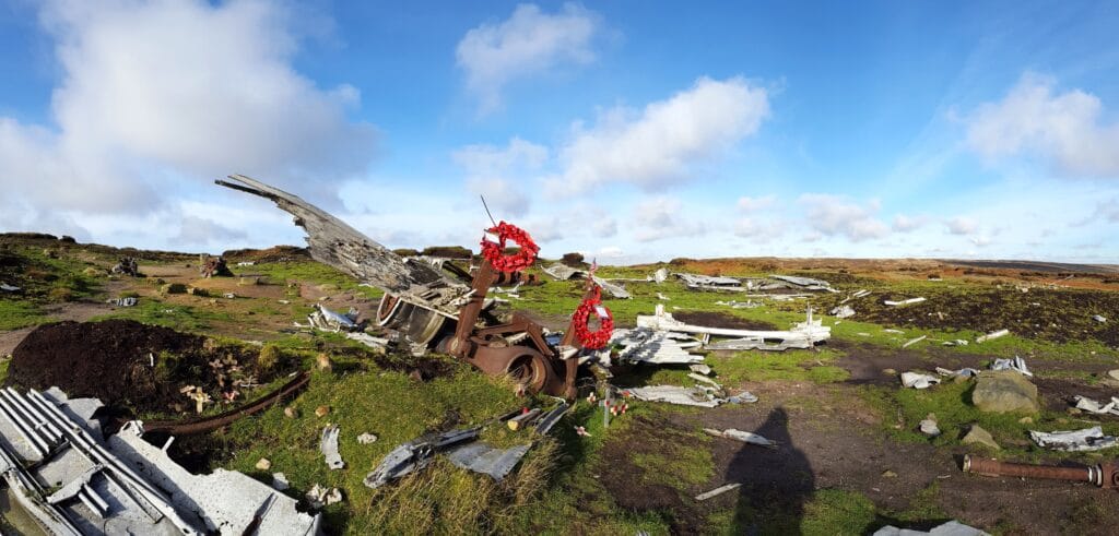
Bleaklow Bomber Crash Site
Hidden among Bleaklow’s windswept moors lies one of the UK’s most famous aircraft wrecks—the remains of the B-29 Superfortress “Over Exposed”, which tragically crashed here in 1948.
 What Happened?
 What Happened?
On November 3, 1948, a US Air Force B-29 bomber was flying from RAF Scampton when it crashed into the hillside of Higher Shelf Stones in thick fog. Tragically, all 13 crew members lost their lives. The aircraft, nicknamed “Over Exposed,” had been used for high-altitude reconnaissance and photography, including documenting nuclear test sites.
What Remains Today?
 What Remains Today?
Unlike many old crash sites, the wreckage is still eerily intact, scattered across the moor as a lasting memorial. You’ll find: Twisted metal remains from the fuselage Propellers and engine parts still embedded in the ground A memorial plaque honoring the lost crew
 How to Visit the Crash Site
- The wreckage sits between Bleaklow Head and Higher Shelf Stones, requiring a short detour from the main trail.
- There are no signs marking the site, so you’ll need good navigation skills or a GPS route.
- Please respect the site—it’s both a historical landmark and a war grave.
 Pro Tip: Visiting in misty conditions makes the site feel even more haunting—but bring a map and compass to avoid getting lost!
Higher Shelf Stones Trig Point
Once you’ve explored the crash site, it’s time to summit Higher Shelf Stones, one of the Peak District’s most underrated viewpoints.
 Why Visit?
- The trig point at 621m marks one of the highest points in the Peak District.
- On a clear day, you’ll get jaw-dropping views stretching as far as Manchester, Kinder Scout, and even Snowdonia!
- The rock formations and rugged landscape around the summit make it a photographer’s dream.
Navigation Tip:
The path to Higher Shelf Stones is not well-defined, so make sure you stay on track using GPS or an OS map.
Bleaklow and Higher Shelf Stones Circular Walk Info
 Route Summary:
- Distance: 6 miles (9.5 km)
- Duration: ~3 to 4 hours
- Difficulty: Moderate (navigation skills required)
- Elevation Gain: ~400m
 Step-by-Step Route Guide:
 Start at Snake Pass (A57) – Park near the Pennine Way access point.
 Follow the Pennine Way north, crossing the moorland towards Bleaklow Head.
 Reach Bleaklow Head cairn – This marks the highest point in the area.
 Take a short detour to the B-29 crash site – The eerie wreckage awaits.
 Continue to Higher Shelf Stones trig point – Enjoy the stunning views.
 Descend back towards Snake Pass via a gentle moorland trail.
 Best Time to Hike:
 Spring & Summer – Warmer conditions, drier paths, and clear views. Autumn – Stunning golden moorland scenery.
 Winter – Navigating in snow or heavy fog can be tricky—only attempt if experienced.
 Facilities & Parking:
- No toilets or shops along the route—bring all essentials.
- Parking available along Snake Pass (A57), but it fills up quickly on weekends.
Bleaklow Conservation Work
Bleaklow might seem like a rugged, untouched wilderness, but in reality, it’s a fragile and constantly changing landscape. Over the years, this moorland has faced everything from erosion and habitat loss to the devastating effects of wildfires and climate change. So, what’s being done to restore and protect this iconic Peak District location?
Let’s dive into the incredible conservation work happening at Bleaklow and how hikers like you can help preserve it for future generations.
Saving Bleaklow’s Moorland
At first glance, Bleaklow might look like an endless stretch of peaty, windswept moors, but beneath the surface, it’s one of the most ecologically significant landscapes in the UK.
🌿 Why is it so important?
✔ Home to rare wildlife – Bleaklow’s heather-covered slopes support mountain hares, curlews, golden plovers, and short-eared owls.
✔ Vital for climate change – The deep peat bogs act as carbon sinks, absorbing CO₂ from the atmosphere.
✔ Part of the Peak District’s unique ecosystem – This area is a Site of Special Scientific Interest (SSSI), meaning it’s legally protected.
But despite its importance, centuries of industrial pollution, wildfires, and human activity have taken a toll. Thankfully, conservation teams are working hard to bring Bleaklow back to life.
How Bleaklow Is Being Restored
So, what’s being done to save Bleaklow’s delicate peatlands and diverse wildlife? Here are some of the key conservation efforts happening right now:
1️⃣ Restoring Peatlands
Bleaklow’s deep peat bogs are like nature’s sponge, storing water and capturing CO₂. But when these bogs erode, they release carbon back into the atmosphere and turn into dry, cracked wastelands.
🔹 Conservation groups, like Moors for the Future, are working to:
✅ Re-wet the moors by blocking drainage channels to stop water loss.
✅ Reintroduce native mosses (like sphagnum moss) to help lock in moisture.
✅ Slow down erosion by planting heather and other moorland vegetation.
💡 Why This Matters: Healthy peatlands are essential for fighting climate change and reducing flash flooding in nearby valleys.
2️⃣ Rewilding & Wildlife Protection
Bleaklow is a haven for moorland birds and mammals, but habitat destruction has put some species at risk. Conservationists are working to:
🐦 Protect breeding sites for birds like curlews and merlins by limiting human disturbance.
🦊 Restore natural habitats for small mammals and insects by planting native flora.
🌾 Remove invasive species that choke out the natural vegetation.
💡 How You Can Help: Stick to designated footpaths to avoid disturbing fragile nesting areas.
3️⃣ Fighting Wildfires & Pollution
Moorland wildfires have devastated parts of Bleaklow in recent years, destroying habitats and damaging the peat bogs beyond repair.
🔥 Preventing Wildfires:
- Conservation groups and local authorities are working to educate hikers and landowners about fire risks.
- Controlled burning is sometimes used to clear dead vegetation safely without allowing wildfires to spread uncontrollably.
- Hikers are encouraged to NEVER use disposable barbecues or campfires in moorland areas.
♻️ Reducing Pollution:
- Volunteers regularly clean up litter from popular hiking trails.
- Projects are underway to limit footpath erosion and reduce the damage caused by heavy foot traffic.
💡 Hiker’s Role: Always follow Leave No Trace principles—pack out everything you bring in!
How You Can Support Bleaklow’s Conservation Efforts
As a hiker, you play a crucial role in helping preserve Bleaklow’s unique landscape. Here’s how you can make a difference:
✅ Stick to marked trails to prevent trampling delicate vegetation.
✅ Avoid walking on peat bogs—they’re easily damaged and take decades to recover.
✅ Respect wildlife by keeping noise levels low and not disturbing nesting birds.
✅ Never light fires or use BBQs—even a small flame can cause catastrophic damage.
✅ Join conservation projects—volunteer with groups like Moors for the Future or donate to help fund moorland restoration.
FAQs About Hiking Bleaklow
Is Bleaklow a mountain? 🏔
No, but it sure feels like one!
Despite its remote and rugged terrain, Bleaklow isn’t technically a mountain—it’s a high moorland plateau. Standing at 633m (2,077ft), it’s one of the highest points in the Peak District, but because it lacks a distinct peak, it’s classified as a hill rather than a mountain.
That said, don’t underestimate Bleaklow! The boggy ground, tricky navigation, and unpredictable weather make it feel just as challenging as some of the UK’s true mountains.
💡 Fun Fact: Bleaklow is actually the second-highest point in the Peak District, just behind Kinder Scout.
How long does it take to climb Bleaklow? ⏳
It depends on your route!
The most popular hike to Bleaklow Head via the Pennine Way from Snake Pass is around 5.5 miles (9 km) round trip and takes 3 to 4 hours at a steady pace.
⏰ Estimated times for different routes:
✔ Snake Pass to Bleaklow Head – ~3 to 4 hours
✔ Bleaklow & Higher Shelf Stones Circular (6 miles) – ~4 to 5 hours
✔ Bleaklow via Wildboar Clough (Challenging Route) – ~5 to 6 hours
💡 Pro Tip: Allow extra time if the weather is poor—Bleaklow’s misty conditions can slow you down significantly!
Is this Bleaklow circular walk suitable for kids? 👨👩👧👦
It depends on their hiking experience.
Bleaklow isn’t the easiest walk for kids, as the terrain can be boggy, uneven, and poorly marked in places. However, if your children are used to longer walks and comfortable with moorland hiking, they should be fine on the Snake Pass to Bleaklow Head route.
👶 For younger kids (under 8):
- The terrain is quite tough, so it may not be the best choice.
- Stick to shorter Peak District walks like Mam Tor or Bamford Edge.
👦 For older kids (8+):
- If they enjoy hiking, the Bleaklow circular route is doable with breaks.
- Make sure they have proper waterproof boots—muddy trails are common!
💡 Family Tip: Want an easier Bleaklow experience? Try walking to the Higher Shelf Stones crash site from Snake Pass (3 miles round trip)—it’s shorter and more engaging for kids.
Where do you park at Bleaklow Head? 🚗
There’s no official car park at Bleaklow Head itself, but you have a few great options nearby.
📍 Best Parking Spots for Bleaklow Hikes:
✔ Snake Pass Layby (A57) – The most popular starting point, with free roadside parking (fills up fast on weekends!).
✔ Torside Reservoir Car Park – A great alternative if Snake Pass is busy, with toilets and better facilities.
✔ Crowden Car Park – Ideal if you’re coming from the south side of Bleaklow.
✔ Old Glossop (Doctor’s Gate) – Best for eastern routes up Bleaklow.
🚗 Parking Tips:
- Arrive early, especially on weekends—Snake Pass fills up quickly.
- Be mindful of weather conditions—Snake Pass can be icy in winter.
- No toilets at Snake Pass—nearest facilities are in Glossop or Torside Reservoir.
💡 Alternative Option: Park at Torside and take the Pennine Way for a longer but scenic route to Bleaklow Head.
How long does it take to climb Bleaklow? ⏳
It depends on which route you take!
⏰ Estimated hiking times for Bleaklow routes:
✔ Snake Pass to Bleaklow Head (most popular) – 3 to 4 hours round trip (~5.5 miles).
✔ Bleaklow & Higher Shelf Stones Circular (6 miles) – 4 to 5 hours.
✔ Bleaklow via Wildboar Clough (challenging route) – 5 to 6 hours.
✔ Longer routes from Torside Reservoir or Crowden – 5 to 7 hours depending on pace.
💡 Pro Tip: Allow extra time if fog rolls in—Bleaklow’s navigation can be tricky in poor visibility.
Where is Bleaklow Head? 📍
Bleaklow Head is the highest point of Bleaklow Moor, located in the northern Peak District, Derbyshire.
📍 Coordinates: 53.4593° N, 1.8585° W
📍 Elevation: 633m (2,077ft)
🔹 How to find it?
- The easiest route is via the Pennine Way from Snake Pass, which leads to the summit cairn at Bleaklow Head.
- It’s north of Glossop and west of the famous Higher Shelf Stones & B-29 crash site.
- The trig point at Higher Shelf Stones (621m) is nearby and often mistaken for Bleaklow Head.
💡 Navigation Tip: GPS is recommended—Bleaklow’s open moorland can be disorienting in poor visibility.
Is Bleaklow a hard walk? 🥾
Yes, but it depends on your experience and the route you take.
🔹 What makes Bleaklow tough?
- Boggy terrain – Expect peat bogs and muddy sections, especially after rain.
- Navigation challenges – Few clear paths, and fog is common.
- Remote and exposed – No shelter, so be prepared for strong winds and changing weather.
🥾 Difficulty rating (1-5):
✔ Beginner-friendly route – Snake Pass to Bleaklow Head (3/5 difficulty) – manageable but still tough in bad weather.
✔ Moderate challenge – Bleaklow Circular & Higher Shelf Stones (4/5) – more varied terrain.
✔ Advanced hikers only – Wildboar Clough & Ashton Clough routes (5/5) – steep, technical, and tricky to navigate.
💡 Safety Tip: Take a map, compass, or GPS—Bleaklow’s featureless moorland is notoriously easy to get lost in!
Find Your Next Walk
Loved exploring Bleaklow Head? There’s so much more to discover! Whether you’re looking for another rugged Peak District challenge or a peaceful countryside stroll, we’ve got you covered.
Discover More Epic Hikes 🥾
If Bleaklow’s wild moorland, tricky navigation, and stunning views left you wanting more, why not take on another adventure?
🔹 For more Peak District challenges:
- Kinder Scout via Crowden Clough – Another tough but rewarding hike with epic gritstone edges.
- Bamford Edge to Stanage Edge – A breathtaking ridge walk with incredible panoramic views.
- Black Hill & Wild boar Clough – If you loved Bleaklow’s remote feel, this one’s for you!
🔹 Prefer something gentler?
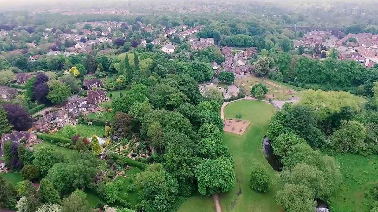
- The Carrs Park, Wilmslow – A relaxing riverside walk perfect for families, just south of Manchester. It’s an easy, scenic stroll along the River Bollin, with picnic spots and a lovely woodland trail. This is the perfect contrast to Bleaklow’s rugged terrain—why not mix up your adventures?
👉 Read our guide to The Carrs Park, Wilmslow and discover this hidden gem!